ADV Navigation
Oct 7, 2013 8:08:26 GMT -6
Post by enduro360son on Oct 7, 2013 8:08:26 GMT -6
After our TART adventure I would like to share the setup for converting .gdb track files to .gpx for use on smartphones, etc. It was pretty easy once I found the right mix of software. Links below are for Win / Mac and Android / Iphone versions.
Instructions below are specific to Win / Android. I purchased Back Country Navigator PRO, but this would work with the DEMO (2 week license?) as I tested it. Both apps have the ability to pre-download maps so they are available while OFFLINE from a service provider. Just keep GPS on and the app will show on the pre-downloaded maps your location.
Garmin BaseCamp (Win or Mac)
www.garmin.com/en-US/shop/downloads/basecamp
Back Country Navigator (Android)
play.google.com/store/apps/details?id=com.crittermap.backcountrynavigator&hl=en
MotionX GPS (Iphone)
itunes.apple.com/us/app/motionx-gps/id299949744?mt=8
Download the .gdb files here.
www.advrider.com/forums/showthread.php?t=629219
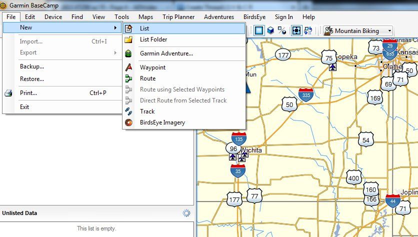
Download, Install, and run BaseCamp. Select File / New / List to start a new track. I renamed mine to TART after creating it.
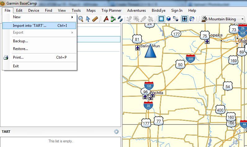
Select File / Import
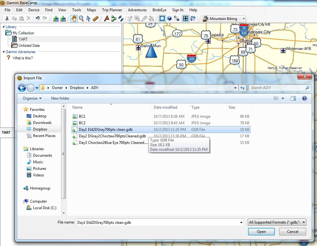
Select the .gdb file to add the track to your new "list". I did this 3 times for each .gdb file.
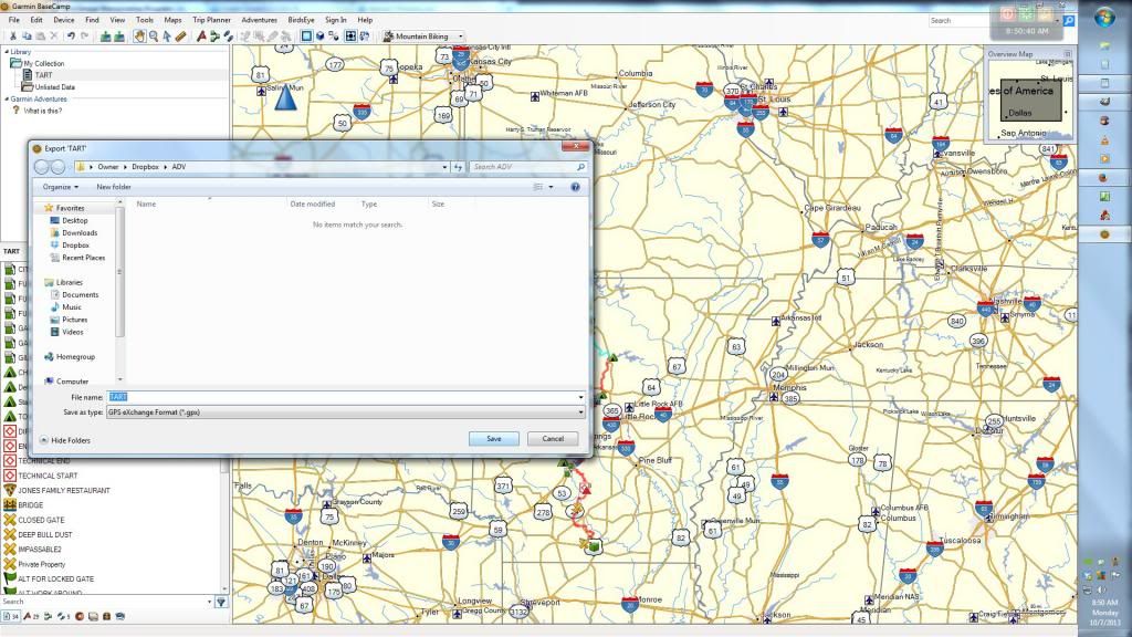
After importing all the .gdb files; select File / Export. Make sure to select the newly created "list" (named TART in example) under "Library / My Collection".
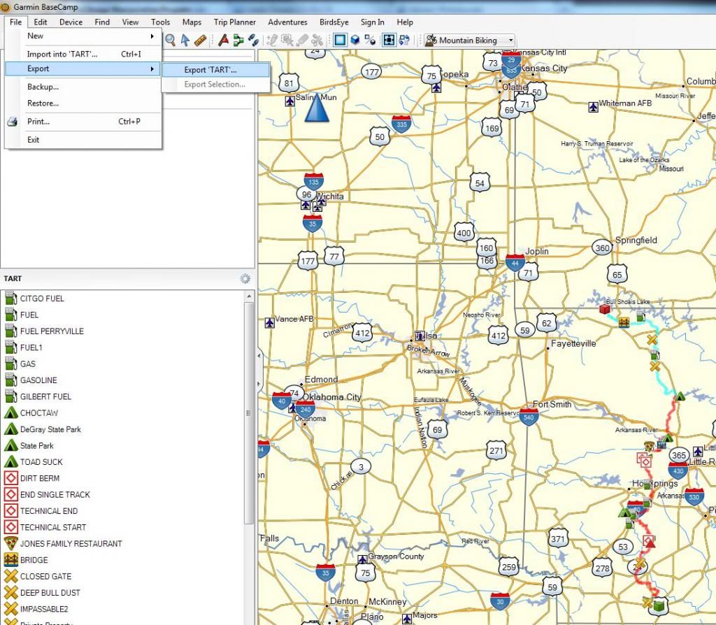
Save your new list as a .gpx file.
Get that .gpx file on your phone. I am assuming if you own a smartphone you know how to do this.
Download and install applicable smartphone app. Then import that .gpx file!
I won't go on yet how to use the Android App, which is extremely robust in features if a little clunky on the interface.
I can't say for Iphone users (Brad may) how to get the file converted within the MotionX app; but it will do it for you. Although I am sure you could use this method as well.
Instructions below are specific to Win / Android. I purchased Back Country Navigator PRO, but this would work with the DEMO (2 week license?) as I tested it. Both apps have the ability to pre-download maps so they are available while OFFLINE from a service provider. Just keep GPS on and the app will show on the pre-downloaded maps your location.
Garmin BaseCamp (Win or Mac)
www.garmin.com/en-US/shop/downloads/basecamp
Back Country Navigator (Android)
play.google.com/store/apps/details?id=com.crittermap.backcountrynavigator&hl=en
MotionX GPS (Iphone)
itunes.apple.com/us/app/motionx-gps/id299949744?mt=8
Download the .gdb files here.
www.advrider.com/forums/showthread.php?t=629219
Download, Install, and run BaseCamp. Select File / New / List to start a new track. I renamed mine to TART after creating it.

Select File / Import

Select the .gdb file to add the track to your new "list". I did this 3 times for each .gdb file.

After importing all the .gdb files; select File / Export. Make sure to select the newly created "list" (named TART in example) under "Library / My Collection".

Save your new list as a .gpx file.

Get that .gpx file on your phone. I am assuming if you own a smartphone you know how to do this.
Download and install applicable smartphone app. Then import that .gpx file!
I won't go on yet how to use the Android App, which is extremely robust in features if a little clunky on the interface.
I can't say for Iphone users (Brad may) how to get the file converted within the MotionX app; but it will do it for you. Although I am sure you could use this method as well.


